ip-details
This is a program that shows all the details of the given IP address. Build with Python and ipinfo.io API
Usage
To use this program, run the main Batch or Shell file, entering an IPv4 address as argument.
$ ip 1.1.1.1
You can also add the --save or -s flag, to save the output to a file. The file will be named details.log, and will be stored inside the saves directory of the program (saves/details.log).
$ ip 1.1.1.1 --save
Or, if prefered:
$ ip 1.1.1.1 -s
Example
$ ip 1.1.1.1

IP : 1.1.1.1
CITY : Miami
REGION : Florida
COUNTRY : US
LOC : 25.7867,-80.1800
ORG : AS13335 Cloudflare, Inc.
POSTAL : 33132
TIMEZONE : America/New_York
MAP : https://maps.google.com/maps/search/25.7867,-80.1800
And with the save option:
$ ip 1.1.1.1 --save
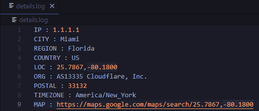
IP : 1.1.1.1
CITY : Miami
REGION : Florida
COUNTRY : US
LOC : 25.7867,-80.1800
ORG : AS13335 Cloudflare, Inc.
POSTAL : 33132
TIMEZONE : America/New_York
MAP : https://maps.google.com/maps/search/25.7867,-80.1800
Data saved to saves/details.log
details.log file:
Requirements
Python programming language
Requests python library (pip install requests)

 1 Jan 01, 2022
 976 Dec 11, 2022
 832 Dec 31, 2022
 11 Mar 02, 2022
 142 Dec 30, 2022
 747 Dec 19, 2022
 3 Nov 16, 2022
 0 Jan 20, 2022
 58 Dec 27, 2022
 1.2k Dec 26, 2022
 4 Dec 25, 2021
 981 Jan 03, 2023
 183 Dec 25, 2022
 13 Nov 27, 2022
 70 Nov 18, 2022
 1 Dec 08, 2021
 649 Jan 01, 2023
 1 Oct 27, 2021
 216 Dec 31, 2022
 34 Dec 04, 2022