QLUSTER is a relative orbit design tool for formation flying satellite missions and space rendezvous scenarios

Related tags

GeolocationQLUSTER
Overview

https://raw.githubusercontent.com/sammmlow/QLUSTER/main/gui/qluster_logo.png

Project: QLUSTER
Github: https://github.com/sammmlow/QLUSTER
Documents: https://example.com/
Version: 0.1 (Unstable)

docs license

Author: Samuel Y. W. Low

linkedin orcid

QLUSTER

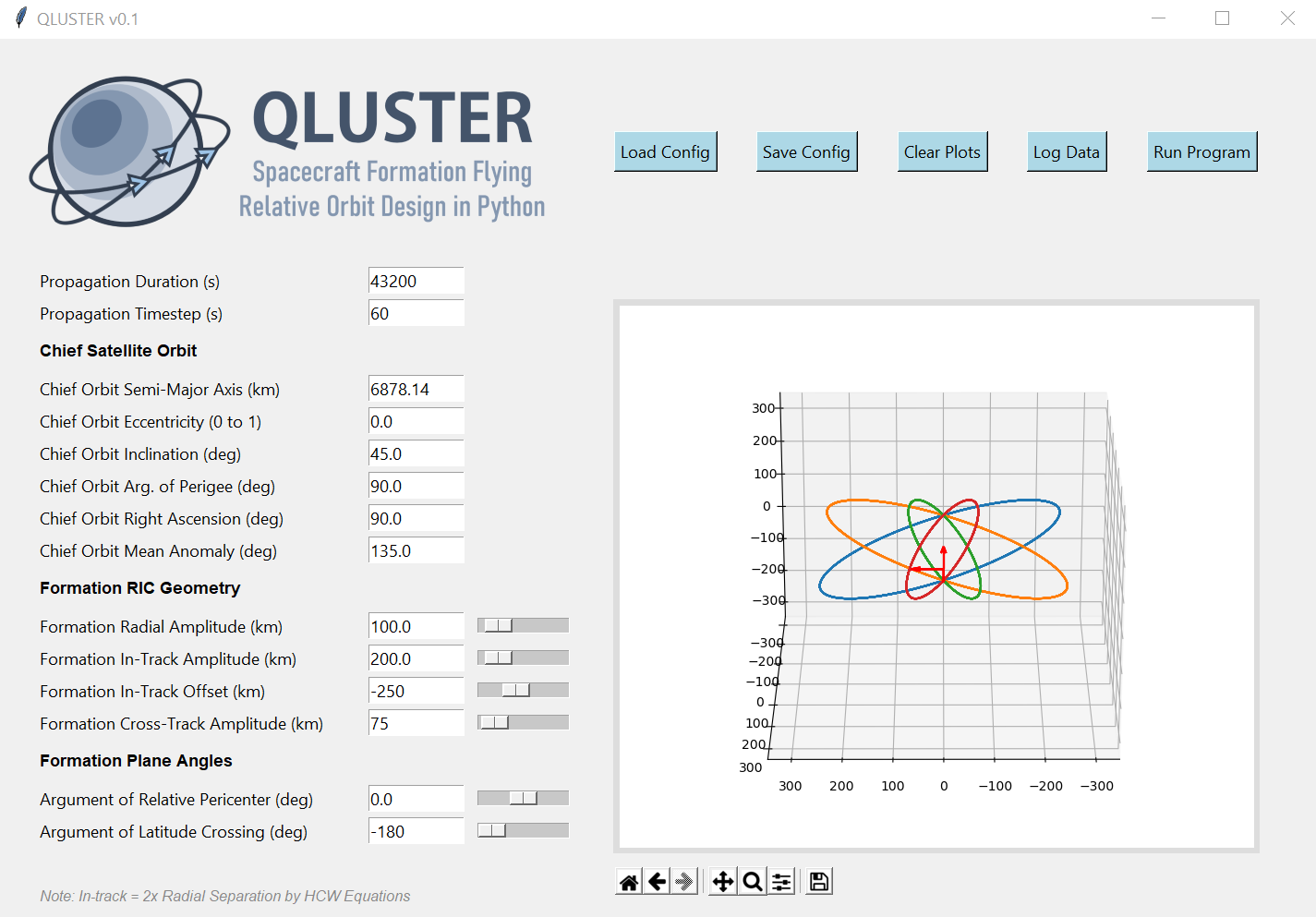
QLUSTER is a relative orbit design tool for formation flying satellite missions and space rendezvous scenarios, that I wrote in Python 3 for my own research and visualisation. It is currently unfinished (95%) but the core algorithm and app works. Here's an example snippet of the GUI where four deputy satellites are orbiting a single chief in LEO.

https://raw.githubusercontent.com/sammmlow/QLUSTER/main/gui/qluster_gui.png

I am open-sourcing it, as I would love to collaborate with you to improve on QLUSTER if you have any cool features to add-on in relation to the design, visualisation, and propagation of the relative astrodynamics!

To-Do List: Documentation, deputy orbit determination, logging of ephemeris etc.

Stretch-Goals: Relative orbit propagation for perturbed orbits, and computation of formation maintenance.


Installation and First Steps

First, clone this repository by running in your terminal (or Git Bash):

git clone https://github.com/sammmlow/QLUSTER.git

Then, just run the main qluster.py file in the main directory, and the GUI should pop up. Have fun!


Other Package Dependencies

To be written


Contact

If you have any queries feel free to reach out to me at:

[email protected]

linkedin orcid

Last Modified on 30-May-2021

Owner
Samuel Low
🌌 Space 🚀 Orbits 📡 Tech 🌏 Earth 🌳 Nature 🐢 Life ♥️
Samuel Low
Spectral decomposition for characterizing long-range interaction profiles in Hi-C maps

Inspectral Spectral decomposition for characterizing long-range interaction prof

Nezar Abdennur 6 Dec 13, 2022
A NASA MEaSUREs project to provide automated, low latency, global glacier flow and elevation change datasets

Notebooks A NASA MEaSUREs project to provide automated, low latency, global glacier flow and elevation change datasets This repository provides tools

NASA Jet Propulsion Laboratory 27 Oct 25, 2022
A part of HyRiver software stack for handling geospatial data manipulations

Package Description Status PyNHD Navigate and subset NHDPlus (MR and HR) using web services Py3DEP Access topographic data through National Map's 3DEP

Taher Chegini 5 Dec 14, 2022
Track International space station with python

NASA-ISS-tracker Track International space station with python Modules import json import turtle import urllib.request import time import webbrowser i

Nikhil Yadav 8 Aug 12, 2021
Location field and widget for Django. It supports Google Maps, OpenStreetMap and Mapbox

django-location-field Let users pick locations using a map widget and store its latitude and longitude. Stable version: django-location-field==2.1.0 D

Caio Ariede 481 Dec 29, 2022
When traveling in the backcountry during winter time, updating yourself on current and recent weather data is important to understand likely avalanche danger.

Weather Data When traveling in the backcountry during winter time, updating yourself on current and recent weather data is important to understand lik

Trevor Allen 0 Jan 02, 2022
A trivia questions about Europe

EUROPE TRIVIA QUIZ IN PYTHON Project Outline Ask user if he / she knows more about Europe. If yes show the Trivia main screen, else show the end Trivi

David Danso 1 Nov 17, 2021
Program that shows all the details of the given IP address. Build with Python and ipinfo.io API

ip-details This is a program that shows all the details of the given IP address. Build with Python and ipinfo.io API Usage To use this program, run th

4 Mar 01, 2022
Automated download of LANDSAT data from USGS website

LANDSAT-Download It seems USGS has changed the structure of its data, and so far, I have not been able to find the direct links to the products? Help

Olivier Hagolle 197 Dec 30, 2022
GetOSM is an OpenStreetMap tile downloader written in Python that is agnostic of GUI frameworks.

GetOSM GetOSM is an OpenStreetMap tile downloader written in Python that is agnostic of GUI frameworks. It is used with tkinter by ProjPicker. Require

Huidae Cho 3 May 20, 2022
A python package that extends Google Earth Engine.

A python package that extends Google Earth Engine GitHub: https://github.com/davemlz/eemont Documentation: https://eemont.readthedocs.io/ PyPI: https:

David Montero Loaiza 307 Jan 01, 2023
Raster processing benchmarks for Python and R packages

Raster processing benchmarks This repository contains a collection of raster processing benchmarks for Python and R packages. The tests cover the most

Krzysztof Dyba 13 Oct 24, 2022
iNaturalist observations along hiking trails

This tool reads the route of a hike and generates a table of iNaturalist observations along the trails. It also shows the observations and the route of the hike on a map. Moreover, it saves waypoints

7 Nov 11, 2022
Python bindings and utilities for GeoJSON

geojson This Python library contains: Functions for encoding and decoding GeoJSON formatted data Classes for all GeoJSON Objects An implementation of

Jazzband 763 Dec 26, 2022
iNaturalist observations along hiking trails

This tool reads the route of a hike and generates a table of iNaturalist observations along the trails. It also shows the observations and the route of the hike on a map. Moreover, it saves waypoints

7 Nov 11, 2022
A Python framework for building geospatial web-applications

Hey there, this is Greppo... A Python framework for building geospatial web-applications. Greppo is an open-source Python framework that makes it easy

Greppo 304 Dec 27, 2022
Starlite-tile38 - Showcase using Tile38 via pyle38 in a Starlite application

Starlite-Tile38 Showcase using Tile38 via pyle38 in a Starlite application. Repo

Ben 8 Aug 07, 2022
A simple reverse geocoder that resolves a location to a country

Reverse Geocoder This repository holds a small web service that performs reverse geocoding to determine whether a user specified location is within th

4 Dec 25, 2021
Earthengine-py-notebooks - A collection of 360+ Jupyter Python notebook examples for using Google Earth Engine with interactive mapping

earthengine-py-notebooks A collection of 360+ Jupyter Python notebook examples for using Google Earth Engine with interactive mapping Contact: Qiushen

Qiusheng Wu 1.1k Dec 29, 2022
Create Siege configuration files from Cloud Optimized GeoTIFF.

cogeo-siege Documentation: Source Code: https://github.com/developmentseed/cogeo-siege Description Create siege configuration files from Cloud Optimiz

Development Seed 3 Dec 01, 2022