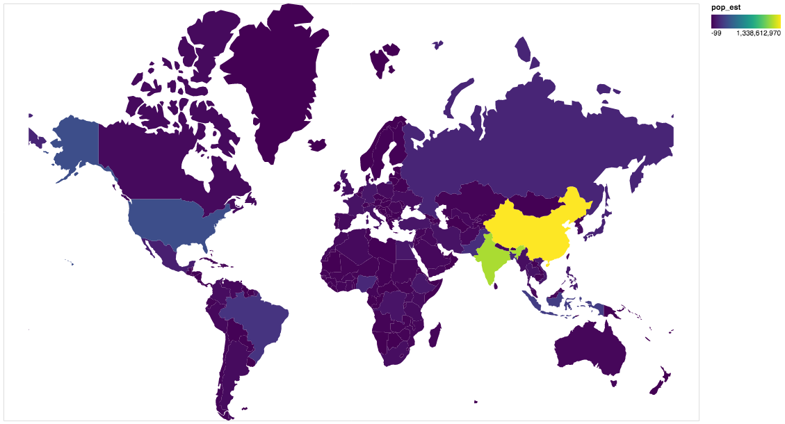
gpdvega is a bridge between GeoPandas and Altair that allows to seamlessly chart geospatial data

Overview

gpdvega Coverage Status Build Status HitCount GitHub license GitHub issues

gpdvega is a bridge between GeoPandas a geospatial extension of Pandas and the declarative statistical visualization library Altair, which allows to seamlessly chart geospatial data using altair.

Example

import altair as alt
import geopandas as gpd
import gpdvega

alt.renderers.enable('notebook') # render for Jupyter Notebook

world = gpd.read_file(gpd.datasets.get_path('naturalearth_lowres'))

# GeoDataFrame could be passed as usual pd.DataFrame
alt.Chart(world[world.continent!='Antarctica']).mark_geoshape(
).project(
).encode(
    color='pop_est', # shorthand infer types as for regular pd.DataFrame
    tooltip='id:Q' # GeoDataFrame.index is accessible as id
).properties(
    width=500,
    height=300
)

output

Install

Dependencies

gpdvega requires:

  • Altair (>= 2.2.0 )
  • GeoPandas (>= 0.4.0)

User installation

using pip

pip install gpdvega

Changelog

See the changelog for a history of notable changes to gpdvega

Spectral decomposition for characterizing long-range interaction profiles in Hi-C maps

Inspectral Spectral decomposition for characterizing long-range interaction prof

Nezar Abdennur 6 Dec 13, 2022
glTF to 3d Tiles Converter. Convert glTF model to Glb, b3dm or 3d tiles format.

gltf-to-3d-tiles glTF to 3d Tiles Converter. Convert glTF model to Glb, b3dm or 3d tiles format. Usage λ python main.py --help Usage: main.py [OPTION

58 Dec 27, 2022
Geospatial web application developed uisng earthengine, geemap, and streamlit.

geospatial-streamlit Geospatial web applications developed uisng earthengine, geemap, and streamlit. App 1 - Land Surface Temperature A simple, code-f

13 Nov 27, 2022
Python bindings and utilities for GeoJSON

geojson This Python library contains: Functions for encoding and decoding GeoJSON formatted data Classes for all GeoJSON Objects An implementation of

Jazzband 765 Jan 06, 2023
Geospatial Image Processing for Python

GIPPY Gippy is a Python library for image processing of geospatial raster data. The core of the library is implemented as a C++ library, libgip, with

GIPIT 83 Aug 19, 2022
An API built to format given addresses using Python and Flask.

An API built to format given addresses using Python and Flask. About The API returns properly formatted data, i.e. removing duplicate fields, distingu

1 Feb 27, 2022
This is the antenna performance plotted from tinyGS reception data.

tinyGS-antenna-map This is the antenna performance plotted from tinyGS reception data. See their repository. The code produces a plot that provides Az

Martin J. Levy 14 Aug 21, 2022
Implementation of Trajectory classes and functions built on top of GeoPandas

MovingPandas MovingPandas implements a Trajectory class and corresponding methods based on GeoPandas. Visit movingpandas.org for details! You can run

Anita Graser 897 Jan 01, 2023
Histogram matching plugin for rasterio

rio-hist Histogram matching plugin for rasterio. Provides a CLI and python module for adjusting colors based on histogram matching in a variety of col

Mapbox 75 Sep 23, 2022
Water Detect Algorithm

WaterDetect Synopsis WaterDetect is an end-to-end algorithm to generate open water cover mask, specially conceived for L2A Sentinel 2 imagery from MAJ

142 Dec 30, 2022
Software for Advanced Spatial Econometrics

GeoDaSpace Software for Advanced Spatial Econometrics GeoDaSpace current version 1.0 (32-bit) Development environment: Mac OSX 10.5.x (32-bit) wxPytho

GeoDa Center 38 Jan 03, 2023
How to use COG's (Cloud optimized GeoTIFFs) with Rasterio

How to use COG's (Cloud optimized GeoTIFFs) with Rasterio According to Cogeo.org: A Cloud Opdtimized GeoTIFF (COG) is a regular GeoTIFF file, aimed at

Marvin Gabler 8 Jul 29, 2022
Xarray backend to Copernicus Sentinel-1 satellite data products

xarray-sentinel WARNING: this product is a "technology preview" / pre-Alpha Xarray backend to explore and load Copernicus Sentinel-1 satellite data pr

B-Open 191 Dec 15, 2022
Processing and interpolating spatial data with a twist of machine learning

Documentation | Documentation (dev version) | Contact | Part of the Fatiando a Terra project About Verde is a Python library for processing spatial da

Fatiando a Terra 468 Dec 20, 2022
Color correction plugin for rasterio

rio-color A rasterio plugin for applying basic color-oriented image operations to geospatial rasters. Goals No heavy dependencies: rio-color is purpos

Mapbox 111 Nov 15, 2022
A package built to support working with spatial data using open source python

EarthPy EarthPy makes it easier to plot and manipulate spatial data in Python. Why EarthPy? Python is a generic programming language designed to suppo

Earth Lab 414 Dec 23, 2022
python toolbox for visualizing geographical data and making maps

geoplotlib is a python toolbox for visualizing geographical data and making maps data = read_csv('data/bus.csv') geoplotlib.dot(data) geoplotlib.show(

Andrea Cuttone 976 Dec 11, 2022
Fiona reads and writes geographic data files

Fiona Fiona reads and writes geographic data files and thereby helps Python programmers integrate geographic information systems with other computer s

987 Jan 04, 2023
Wraps GEOS geometry functions in numpy ufuncs.

PyGEOS PyGEOS is a C/Python library with vectorized geometry functions. The geometry operations are done in the open-source geometry library GEOS. PyG

362 Dec 23, 2022
scalable analysis of images and time series

thunder scalable analysis of image and time series analysis in python Thunder is an ecosystem of tools for the analysis of image and time series data

thunder-project 813 Dec 29, 2022